This stretch of the South West Coast Path is arguably the finest coastal geology walk in Britain, showcasing the immense power of continental collision and the dramatic process of deep-sea sedimentation. The cliffs expose deep-marine rocks of the Upper Carboniferous period, deposited more than 300 million years ago.
Quick Summary (for the casual reader)
- Walkers can see perfect zig-zag folds, tilted strata, ripple marks, faults, and other dramatic features — especially around Millook Haven.
- The cliffs are made of layers of sandstone and shale laid down in a deep-water basin around 300 million years ago.
- Huge underwater sediment flows created thick sand layers; quiet periods left thin mud layers.
- Millions of years later, a massive continental collision folded and crumpled these rocks.
1. 🏞️ General Description: A World-Class Geological Showcase
The towering, dark cliffs between Bude and Crackington Haven are composed of rocks from the Carboniferous Period, laid down between roughly 310 and 300 million years ago.
The geology can be simplified into two main groups, which you will walk across:
The Striped Cliffs of Bude (The Bude Formation)
- Location: Dominates the cliffs around Bude, including Compass Point.
- Appearance: This rock sequence is characterized by thick, repetitive, or “striped” bands of rock.
- Composition: Alternating layers of hard, pale sandstone and softer, darker shale (or mudstone). The hard sandstones resist erosion and form the prominent ridges and headlands.
The Darker Cliffs of Crackington (The Crackington Formation)
- Location: Dominates the cliffs south of Widemouth Bay towards Crackington Haven.
- Appearance: As you walk south, the cliffs gradually become darker and the rock layers are visibly thinner and more intensely crumpled.
- Composition: Primarily thinner-bedded shales and siltstones. These softer rocks erode more easily, often creating the steep, secluded bays and coves.
The sheer thickness of these sediments—estimated to be over 1.3 kilometres deep—tells a story of continuous, rapid deposition over millions of years.
2. 💥 How This Geology Came About: From Deep Sea to Mountain Range
The present-day appearance of the cliffs is the result of two colossal events:
A. The Deep-Sea Dump: Flysch Sedimentation
When these rocks were first forming, the area that is now Cornwall was part of a deep marine basin, often referred to as ‘Lake Bude’ situated near the ancient supercontinent of Gondwana.
- The Process: The rocks were created by vast, episodic submarine avalanches called turbidity currents. These were fast-flowing, dense slurries of sediment—sand, mud, and silt—washed off a massive continental shelf and down a slope into the deep basin.
- The Layers: Each turbidity current pulse settled out rapidly, creating a graded bed:
- Coarse sand settled first, forming the base of the hard sandstone layer.
- Fine silt and mud settled last, forming the top of the layer and the interbedded shale/mudstone.
- The Result: The result is called flysch sedimentation—a rhythmic, layered stack of rock created by high-energy events followed by long periods of calm. Geologists sometimes refer to this ancient water body as the “Culm Basin.”
B. The Continental Crunch: The Variscan Orogeny
The second event was a mountain-building phase that dramatically crumpled and contorted these flat-lying layers.
- The Collision: During the Late Carboniferous to Early Permian periods, the ancient supercontinent Gondwana collided with Laurussia (which included North America and Europe). This massive, slow-motion crunch closed an ancient ocean and formed the supercontinent Pangaea.
- The Stress: Southwest England lay on the edge of this vast collision zone. The intense, long-term north-south compressional forces squeezed the sedimentary rocks.
- The Effect: The stress buckled the alternating hard sandstone and soft shale layers like a rug being pushed together, creating the dramatic folds and faults you see today. This is why the rocks are no longer flat but tilted, twisted, and in some places, standing nearly vertical.
3. 🔎 What to Look For: Unmissable Examples Along the Path
The walk is an outdoor classroom for structural geology. Here are the exceptional features to watch out for from the Coast Path (always observe cliffs from a safe distance):
1. Compass Point & Maer Cliffs
What to spot:
- Steeply dipping layers of sandstone and shale
- Beautiful graded beds
- Ripple marks and cross-bedding
- The “Whale’s Back” — a curved, resistant sandstone ridge
This is an ideal introduction to the Bude Formation and deep-water layering.
2. Black Rock & Widemouth Bay
Fantastic low-tide exposures.
Look for:
- Classic thick sandstone / thin shale alternations
- Small slump folds from ancient seafloor mudslides
- Load structures and flute casts beneath sandstone beds
- Ripple marks on bed tops
A superb textbook example of deep-water “flysch” deposits.
3. Transition to the Crackington Formation
South of Widemouth, the character of the cliffs gradually changes.
Look for:
- Thinner, darker layers
- Softer, more fissile shales
- A general shift from tough sandstone ledges to smoother slopes
This marks your movement into deeper parts of the ancient basin.
4. Millook Haven – The Famous Zig-Zag Chevron Folds
A must-see geology landmark
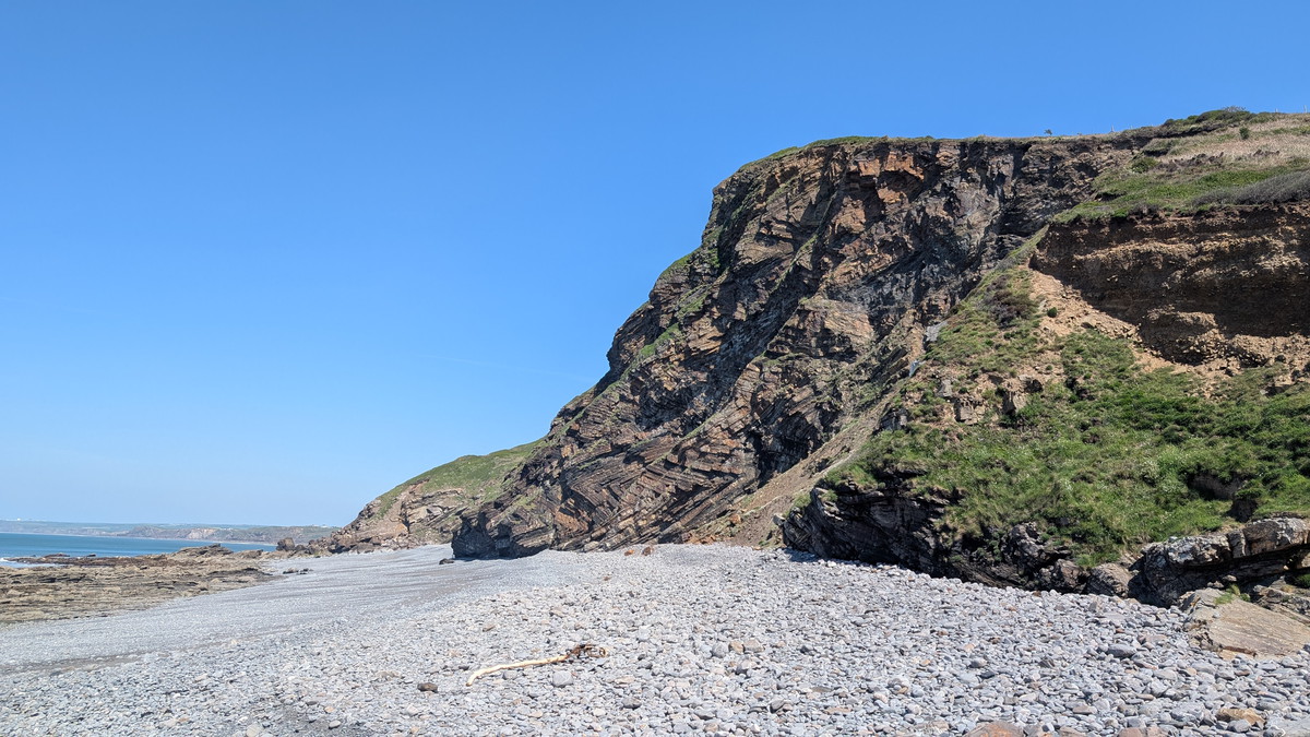
These cliffs are one of the most-photographed geological features in Britain.
Look for:
- Perfect, sharp chevron folds
- Repeating zig-zag patterns
- Alternating sandstone “ribs” and shale “hinges”
- Steep, near-vertical layers
The folds formed when the stronger sandstone beds resisted bending while the weaker shales compressed more easily — producing this spectacular geometry.
5. Castle Point & Pencannow Point
A superb viewpoint for understanding the larger structures.
Look for:
- Big, open folds in the cliff faces
- Tilted slabs and repeated dip patterns
- Clear fault planes
- Interbedded grey mudstones and clean sandstone ribs
This is one of the best places to visualise how the entire basin was squeezed.
6. Crackington Haven – The Type Section
This is the classic exposure of the Crackington Formation.
Look for:
- Thin-bedded shales folded into complex patterns
- Pencil cleavage in mudstones
- Small-scale fold interference patterns
- Quartz veins and pressure-solution seams
At low tide, the wave-cut platforms reveal exquisite small-scale structures.
Key Takeaway for the Walker
The high, dramatic headlands are built from the tough, resistant sandstones of the ancient deep-sea avalanches, while the beautiful, sheltered coves are formed where the softer shales have been eroded. The scenery you see is a direct result of these ancient geological forces.